Blog & News
Race/Ethnicity Data in CMS Medicaid (T-MSIS) Analytic Files: 2021 Data Assessment
December 6, 2023:The Transformed Medicaid Statistical Information System (T-MSIS) is the largest national database of current Medicaid and Children’s Health Insurance Program (CHIP) beneficiary information collected from U.S. states, territories, and the District of Columbia (DC).1 T-MSIS data are critical for monitoring and evaluating the utilization of Medicaid and CHIP, which together provide health insurance coverage to almost 90 million people.2
Due to their size and complexity, T-MSIS data files are challenging to use directly for research and analytic purposes. To optimize these files for health services research, Centers for Medicare and Medicaid Services (CMS) repackages them into a user-friendly, research-ready format called T-MSIS Analytic Files (TAF) Research Identifiable Files (RIF). One such file, the Annual Demographic and Eligibility (DE) file, contains race and ethnicity information for Medicaid and CHIP beneficiaries. This information is vital for assessing enrollment, access to services, and quality of care across racial and ethnic groups in the Medicaid/CHIP population, whose members are particularly vulnerable due to limited income, physical and cognitive disabilities, old age, complex medical conditions, housing insecurity, and other social, economic, behavioral, and health needs.
To guide researchers and other consumers in their use of T-MSIS data, CMS produces data quality assessments of the completeness of race and ethnicity data along with other data such as enrollment, claims, expenditures, and service use. The Data Quality (DQ) assessments for race and ethnicity data have been posted for data years 2014 through 2021 and indicate varying levels of “concern” regarding race and ethnicity data completeness. Some data years have multiple data versions (e.g., Preliminary, Release 1, Release 2), each with their own DQ assessment.
While completeness of race and ethnicity data reported to CMS has historically remained inconsistent among the states, territories, and DC, SHADAC has been monitoring the quality of these data over time. We are excited to discuss a noticeable improvement in quality as discussed below. This blog explores not only the 2021 Data Release 1, the most recent T-MSIS race and ethnicity data for which a DQ assessment is available, but also a brief analysis of data quality trends over time that we plan to follow in future T-MSIS file releases.
Evaluation of T-MSIS Race and Ethnicity Data
DQ assessments for each year and data version of T-MSIS data are housed in the Data Quality Atlas (DQ Atlas), an online evaluation tool developed as a companion to T-MSIS data.3 The DQ Atlas assesses T-MSIS race and ethnicity data using two criteria: the percentage of beneficiaries with missing race and/or ethnicity values in the TAF; and the number of race/ethnicity categories (out of five) that differ by more than ten percentage points between the TAF and American Community Survey (ACS) data. Taken together, these two criteria indicate the level of “concern” (i.e., reliability) for states’ T-MSIS race/ethnicity data. To construct the external ACS benchmark for evaluating T-MSIS data, creators of the DQ Atlas combine race and ethnicity categories in the ACS to mirror race and ethnicity categories reported in the TAF (see Table 1). More information about the evaluation of T-MSIS race and ethnicity data is available in the DQ Atlas’ Background and Methods Resource.
Five “concern” categories appear in the DQ Atlas: Low Concern, Medium Concern, High Concern, Unusable, and Unclassified. States with substantial missing race/ethnicity data or race/ethnicity data that are inconsistent with the ACS – a premier source of demographic data – are grouped into either the High Concern or Unusable categories, whereas states with relatively complete race/ethnicity data or race/ethnicity data that align with ACS estimates are grouped into either the Low Concern or Medium Concern categories. The Unclassified category includes states for which benchmark data are incomplete or unavailable for a given data year and version.
Table 1. Crosswalk of Race and Ethnicity Variables between the TAF and ACS
| Race/Ethnicity Category |
Race/Ethnicity Flag Value in TAF |
Combination of Race and Hispanic Variables in ACS |
| Hispanic, all races |
7=Hispanic, all races | Hispanic, all races |
| Other races, non-Hispanic |
4= American Indian and Alaska Native, non-Hispanic 5=Hawaiian/Pacific Islander 6=Multiracial, non-Hispanic |
- American Indian alone - Alaska Native alone - American Indian and Alaska Native tribes specified; or American Indian or Alaska native, non-specified and no other race - Native Hawaiian and other Pacific Islander alone - Some other race alone - Two or more races |
Source: Medicaid.gov. (n.d.). DQ Atlas: Background and methods resource [PDF file]. Available from https://www.medicaid.gov/dq-atlas/downloads/background-and-methods/TAF-DQ-Race-Ethnicity.pdf Accessed December 1, 2023.
Quality Assessment by State
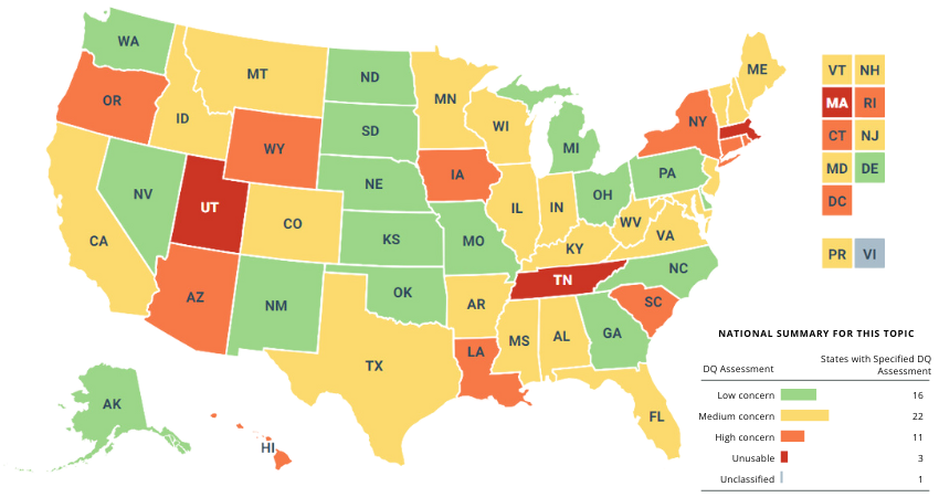
Table 2 shows the Race and Ethnicity DQ Assessments for the 2021 TAF (Data Version: Release 1). The categorization criteria used to determine the levels of concern for the 2021 TAF Release 1 data are the same as those used to assess T-MSIS data from previous years and versions. 16 states received a rating of “Low Concern.” There were 22 states (including Puerto Rico [PR]) that fell into the “Medium Concern” category.
Most of the “Medium Concern” states (19 of 22) fell into the subcategory denoting the higher percentage range of missing race/ethnicity data (from 10 percent up to 20 percent). A similar pattern can be seen among the “High Concern” states, most of which (8 of 11) fell into the subcategory denoting the highest percentage range of missing race/ethnicity data (from 20 percent up to 50 percent).
Finally, 11 states (including DC) received a rating of “High Concern.” Three states (Massachusetts, Tennessee, and Utah) received an “Unusable” rating, as each of these states was missing at least 50 percent of race/ethnicity data. The Virgin Islands (VI) is the only state/territory categorized as “Unclassified” in the 2021 TAF (Data Version: Release 1) due to insufficient or incomplete data, and does not appear in Table 2.
Table 2. Race and Ethnicity Data Quality Assessment, 2021 T-MSIS Analytic File (TAF) Data Release 1
| Data quality assessment |
Percent of beneficiaries with missing race/ethnicity values | Number of race/ethnicity categories where TAF differs from ACS by more than 10% |
Number of states* |
States |
| Low Concern | <10% | 0 | 16 | AK, DE, GA, KS, MI, MO, NE, NV, NM, NC, ND, OH, OK, PA, SD, WA |
| Medium Concern | <10% | 1 or 2 | 3 | ID, IL, VA |
| 10% - <20% | 0 or 1 | 19 | AL, AR, CA, CO, FL, IN, KY, ME, MD, MN, MS, MT, NH, NJ, PR, TX, VT, WV, WI | |
| High Concern | <10% | 3 or more | 1 | RI |
| 10% - <20% | 2 or more | 2 | AZ, LA | |
| 20% - <50% | Any value | 8 | CT, DC, HI, IA, NY, OR, SC, WY | |
| Unusable | >50% | Any value | 3 | MA, TN, UT |
Notes: *T-MSIS includes all 50 states, the District of Columbia (DC), and the U.S. territories of Puerto Rico (PR) and the Virgin Islands (VI). However, a DQ assessment is not available for VI in the 2021 TAF (Data Version: Release 1) due to incomplete/unavailable data.
Despite ongoing variation in the completeness of race and ethnicity data reported to CMS, SHADAC researchers have noted a trend toward better quality data overall. Since beginning to track these quality assessments with the 2019 T-MSIS TAF release, a number of states have shifted up the quality assessment scale with noticeably fewer states seeing their data classified as “High Concern.” Specifically, 2021 race/ethnicity TAF data from 11 states received a rating of “High Concern” compared to 16 states’ data in 2020 and 17 states’ data in 2019. The number of states with “Unusable” data has also dropped each year – 3 states’ 2021 race/ethnicity TAF data was classified as “Unusable” compared to 4 states’ data in 2020 and 5 states’ data in 2019.
Visualizing T-MSIS Data in the DQ Atlas
The DQ Atlas enables users to generate maps and tables that compare the quality of T-MSIS data between states across different topics, such as race/ethnicity, age, income, and gender (see Figure 1). Visualizing T-MSIS data in this manner can help researchers quickly assess the completeness of a single variable as well as the relative completeness (or incompleteness) of certain variables compared to others. For example, in the 2021 TAF Data Release 1, all states and territories received a “Low Concern” rating for age data, whereas only 31 states and territories received a “Low Concern” rating for family income.
Figure 1. Data Quality Assessments of Beneficiary Information by U.S. State/Territory
Notes: Green = low concern; yellow = medium concern; orange = high concern; red = unusable; grey = unclassified.
Source: Medicaid.gov. (n.d.). DQ Atlas: Race and Ethnicity [2021 Data set: Version: Release 1]. Available from https://www.medicaid.gov/dq-atlas/landing/topics/single/map?topic=g3m16&tafVersionId=35 Accessed December 1, 2023.
Looking Ahead
Increasingly, a wide diversity of voices from non-profits, health insurers, state-based marketplaces, and policymakers have called for improving the collection of race, ethnicity, and language data, often with the goal of advancing health equity. CMS’s efforts to improve the quality and availability of T-MSIS data reflect this nationwide movement toward data collection practices that more accurately capture the diversity of the U.S. population.
SHADAC was excited to see the revised Office of Management and Budget (OMB) standards related to the collection of race and ethnicity data. The proposed revisions align with available evidence, are consistent with the changes made by leading states, and, most importantly, explicitly state that these standards should serve as a minimum baseline with a call to collect and provide more granular data. However, while these standards are specifically named as minimum reporting categories for data collection throughout the Federal Government, if adopted they are likely to shape data collection and reporting across all sectors, including the states that collect race/ethnicity data through the Medicaid application process.
Many states express difficulties reporting data, as there is misalignment in how state eligibility systems, Medicaid Management Information System (MMIS), and T-MSIS format race and ethnicity data. Before states submit data to T-MSIS, they must reformat and aggregate data, which may affect the quality of submitted data. One approach to improve the collection and reporting of data is providing states with an updated model application using evidence-based approaches to race and ethnicity questions that improve applicant response rate and data accuracy.
Sources
1 Medicaid.gov. Transformed Medicaid Statistical Information System (T-MSIS). Retrieved October 20, 2022, from https://www.medicaid.gov/medicaid/data-systems/macbis/transformed-medicaid-statistical-information-system-t-msis/index.html#
2 Medicaid.gov. August 2023 Medicaid & CHIP Enrollment Data Highlights. Retrieved on December 1, 2023, from https://www.medicaid.gov/medicaid/program-information/medicaid-and-chip-enrollment-data/report-highlights/index.html3 Saunders, H., & Chidambaram, P. (April 28, 2022). Medicaid Administrative Data: Challenges with Race, Ethnicity, and Other Demographic Variables. Kaiser Family Foundation. Retrieved October 31, 2022, from https://www.kff.org/medicaid/issue-brief/medicaid-administrative-data-challenges-with-race-ethnicity-and-other-demographic-variables/
4 Wang, H.L. (June 15, 2022). Biden officials may change how the U.S. defines racial and ethnic groups by 2024. NPR. Retrieved November 1, 2022, from https://www.npr.org/2022/06/15/1105104863/racial-ethnic-categories-omb-directive-15
5 Diaz, J. (August 16, 2022). California becomes the first state to break down Black employee data by lineage. NPR. Retrieved November 1, 2022, from https://www.npr.org/2022/08/16/1117631210/california-becomes-the-first-state-to-break-down-black-employee-data-by-lineage
6 The New York State Senate. (December 22, 2021). Assembly Bill A6896A. Retrieved November 2, 2022, from https://www.nysenate.gov/legislation/bills/2021/A689
Publication
Federal Survey Sample Size Analysis: Disability, Language, and Sexual Orientation and Gender Identity
The Medicaid and CHIP Payment and Access Commission contracted with the State Health Access Data Assistance Center (SHADAC) to conduct a review and sample size analysis of 13 federal population health surveys to assess the quality and availability of data for certain populations facing health inequities, including people with disabilities, language access needs, and people who indicate their sexual orientation or gender identity (SOGI). This brief provides an overview of each federal survey and identifies which surveys included questions about disability, primary language, limited English proficiency (LEP), and sexual orientation and gender identity (SOGI). Below is an overview table of the Federal surveys included in this analysis.
| Federal Survey | Periodicity | Target Population | States, DC, and Territories Represented | Most Recent Data Year | Total Population Unweighted Sample Size | Total Unweighted Sample Size for Medicaid 1 |
|---|---|---|---|---|---|---|
| ACS | Annual | Civilian, non-institutionalized U.S. population | 50 states, D.C., Puerto Rico | 2021 | 3,252,599 | 434,900 |
| BRFSS | Annual | U.S. adults > 18 years | 49 states (no Florida in 2021), D.C., Guam, Puerto Rico, Virgin Islands | 2021 | 438,693 | 50,306 |
| CPS | Annual | Civilian, non-institutionalized U.S. population | 50 states, D.C. | 2022 | 152,732 | 24,155 |
| HPS | Panel | U.S. adults > 18 years | 50 states, D.C. | 2023 | 59,290 | 2,764 |
| MEPS-HC2 | Panel | Civilian, non-institutionalized U.S. population | No state estimates | 2020 | 27,805 | 6,504 |
| MCBS3 | Annual | All individuals enrolled in Medicare | No state estimates | 2020 | 13,916 | 2,593 |
| NAMCAHPS4 | Fielded once | Adults enrolled in Medicaid | 50 states, D.C. | 2014 | 272,679 | 272,679 |
| NHANES | Periodic | Civilian, non-institutionalized U.S. population | No state estimates | 20205 | 9,254 | 2,841 |
| NHIS | Annual | Civilian, non-institutionalized U.S. population | 50 states, D.C. when two years combined in the RDC | 2022 | 35,115 | 4,918 |
| NSCH6 | Annual | U.S. children < 18 years | 50 states, D.C. when two years combined | 2021 | 50,892 | 11,259 |
| NSDUH | Annual | Civilian, non-institutionalized U.S. population, age 12 + | No state estimates | 2021 | 58,034 | 11,008 |
| PRAMS | Annual | Pregnant women in 47 states, D.C., and Puerto Rico | See target population | 2021 | NA | NA |
| SIPP7 | Panel | Civilian, non-institutionalized U.S. population | 50 states, D.C. | 2022 | 40,510 | 5,835 |
1 Unless otherwise noted, where relevant, Medicaid was defined using the typical MACPAC hierarchy:
(1) Medicare; (2) Private with no Medicare; (3) Medicaid with no Medicare or private; (4) Other type of insurance with no Medicare or private; (5) Uninsured all year
2 Medicaid coverage was defined based on the most recent date of data collection (e.g., December).
3 MCBS data uses “full year dual” to define Medicaid, meaning people who were enrolled in Medicare and Medicaid all year.
4 NAMCAHPS limited to adults enrolled in Medicaid.
5 Sample size analysis conducted using 2017-2018 file, because of pandemic impacts on data collection in 2020.
6 The NSCH includes three categories of children’s coverage (public, private, uninsured); we code children in public coverage as having Medicaid, because Medicare is much less common among children.
7 SIPP data uses the annual coverage variables to define Medicaid.
Source: SHADAC analysis of federal survey data.
The findings show that the majority of surveys include questions to identify individuals with a functional disability. Still, fewer than half of these surveys include questions about intellectual disability, serious mental illness, primary language, LEP, and SOGI. Of the surveys that include these questions, the majority have a sufficient sample for reporting about Medicaid-covered individuals for each demographic group.
Blog & News
Considerations from SHADAC: Proposed Revisions to Federal Standards for Collecting Race/Ethnicity Data
March 23, 2023:
|
On January 26, 2023, the Interagency Technical Working Group on Race and Ethnicity Standards released an initial set of recommended revisions to the Office of Management and Budget’s (OMB) Statistical Policy Directive No. 15: Standards for Maintaining, Collecting, and Presenting Federal Data on Race and Ethnicity (SPD 15). SHADAC summarized the proposed revisions to the OMB standards in a recent State Health & Value Strategies Expert Perspective. The public was invited to provide comment on the proposed revisions, and below, we provide text from the feedback that SHADAC submitted to Dr. Karin Orvis, Chief Statistician of the United States, in response to these revisions. We encourage other interested parties to also submit their comments, especially those who can provide state-level perspectives such as state data analysts and policymakers. |
Response from SHADAC
The State Health Access Data Assistance Center (SHADAC) is a health policy research center within the University of Minnesota School of Public Health. We provide technical assistance (TA) to states in the areas of data use and analysis to support policy. The below comments are based on SHADAC’s specific experience supporting states as they address challenges related to the collection of data on race, ethnicity, language, disability, sexual orientation, and gender identity via the Medicaid application.
SHADAC was thrilled to see the revised OMB standards related to the collection of race and ethnicity. The proposed revisions align with available evidence, are consistent with the changes made by leading states, and most importantly, explicitly state that these standards should serve as a minimum baseline with a call to collect and provide more granular data. However, while these standards are specifically named as minimum reporting categories for data collection throughout the Federal Government, if adopted, they are likely to shape data collection and reporting across all sectors, including the states with whom we work that collect race/ethnicity data through the Medicaid application process.
State Medicaid programs have the flexibility to develop their own applications and race and ethnicity questions as long as they meet CMS-established reporting requirements (which follow current OMB guidance). Although many states follow the application model that CMS developed in 2013, our research has found 65 different variations in how these data are collected across all states and modes (e.g., paper, online). Once collected, this information is used in a wide variety of ways: to support state analysis and operation; in reporting to CMS; and to feed into the T-MSIS, which in turn is released as the research-ready T-MSIS data files used by researchers studying Medicaid program health outcomes, health equity, and administrative accountability.
Given the role OMB standards play in shaping state data collection approaches and the obvious impact and reach of these data, we respectfully submit our comments aimed at supporting the adoption of a revised set of standards.
Cross Program and Agency Alignment
Guidance needs to include detail on how any revisions will filter through data collection and reporting across all sectors that impact states/federal interactions. Will all federal agencies adopt the proposed new standards on the same timeline?
For example, all Food and Nutrition Services (FNS) state agencies are currently required to collect race and ethnicity according to prescribed specifications: race and ethnicity must be collected using a two-question format (ethnicity must be collected before race), and the minimum categories must align with OMB standards. Therefore, states with a combined Medicaid/SNAP application currently cannot offer a combined race/ethnicity question even though the most current evidence shows that is the preferred approach. States will want to know whether the adoption of the new proposed OMB standard allowing for a combined race/ethnicity question will supersede the existing FNS guidance on how to collect this information. Or will states that want to pursue a combined question on their combined Medicaid/SNAP application have to wait for updated FNS guidance to be released?
Similarly, existing guidance requires states to share data (including demographic data like race and ethnicity) with health plan carriers via a federally standardized 834 template. States cannot make changes to existing data fields on this form—any changes made currently result in enrollment transaction failures. If OMB standards are updated, how and when will changes be made to the 834 file form to align with these new changes?
Finally, the revisions have implications for state data reporting of race and ethnicity into the Transformed Medicaid Statistical Information System (T-MSIS). If approved, states will need guidance on how to transition to a single data element (combined race and ethnicity). They will need to understand how to streamline or roll-up more granular data and more write-in data and how to manage the likely increase in people who report more than one race.
Data Granularity
The revised guidance rightfully acknowledges the challenges associated with collecting more granular data. If the final guidance recommends the inclusion of an open text response option for each detailed category, states will need detailed, individual guidance on how best to manage those data. While most states prioritize granularity, they simply don’t have the staff time or, in some cases, the expertise to develop the thoughtful and detailed cleaning and coding procedures required to process a large volume of write-in data. In addition, many current IT systems don’t have the functionality to collect and store a large volume of write-in data.
One way to support this would be to develop or enhance an existing hierarchy that includes a long and diverse list of racial and ethnic categories, such as the Centers for Disease Control Race Category and Ethnicity Groupings. Another way to support the use and reporting of disaggregated data is to provide technical support and guidance around data use standards. This could include standards around recency, maximum “refusal to answer” thresholds, data missingness thresholds, and sample size thresholds that guide suppression of publication.
Technical Assistance
States need direct technical assistance (TA) to support the successful implementation of revised standards. This will need to go beyond documentation and guidance. To do this well, states should have access to experts who can provide practical, hands-on advice that is responsive to their specific needs. The type of assistance needed will vary. States with sophisticated analytic teams may seek advice on how to bridge race and ethnicity data collected under one method with data collected under a revised method. Other states may need more fundamental support to implement the expanded race/ethnicity option in a way that is the least disruptive to their current data collection structure.
We would also recommend that any TA effort include a forum for states to discuss implementation challenges with their peers and serve as a repository for promising practices. States will face different challenges but always appreciate having a forum to discuss problems and solutions with other state officials. In addition, there is limited research on best ways to collect data on race and ethnicity and even less on operational considerations for collecting this information in an administrative context like a Medicaid application. Technical assistance should encourage and support the evaluation of systems’ improvements and serve as a clearinghouse for sharing key findings.
To build trust with the enrollees from whom this data is being collected, states would also benefit from technical assistance or model training materials on the best ways to communicate why this data is being collected and how it is being used (e.g., TA on effective forms of community engagement, Navigator or assister training, or instructional language scripts for frontline workers.)
Funding
Questions that collect race and ethnicity data within the Medicaid application are embedded in many other complex and multifaceted questions about topics such as employment, income, household composition, etc. The systems that collect and house this information vary in their age, technical capacity, and purpose. Almost uniformly, they are complex and expensive to change, both in terms of data collection but also data transfer, reporting, and sharing. Ideally, states can access new dedicated funding or receive clear guidance on how existing federal money can be used to make necessary IT and systems changes.
The funding associated with this effort should also be flexible. It should support direct costs like system modifications but also priorities such as stakeholder engagement, instructional language development, and training—all of which are critical to successfully implementing the revised data collection guidance.
Urgency of Additional Guidance
While we are encouraged to see revised standards related to race and ethnicity data collection, we want to stress the urgency of revised guidance related to data collection on sexual orientation, gender identity, primary language, and disability. The current standards on sex are woefully inadequate, to the point of causing harm to people who identify as belonging to a sexual or gender minority population. Standards around disability and language are similarly lacking. Given the intersectionality of these concepts as they relate to identity, it’s important to make progress on updating standards for all areas, not just one. In addition, if states are to make significant investments to modify application wording as well as data systems and reporting structures to improve the collation of race and ethnicity, it makes sense to do this with the knowledge and understanding of timing for future changes regarding sexual orientation, gender identity, primary language, and disability. At the best, these timelines could be aligned, and at the least, states should have visibility to when those revisions are likely to be released.
Blog & News
Review of Health Insurance Coverage Data in 2021: Releases and Resources
February 27, 2023:Each year, SHADAC covers the releases of health insurance coverage data from major federal surveys such as the American Community Survey (ACS) and Current Population Survey (CPS), both of which are overseen by the U.S. Census Bureau.1 Not only do these data provide an understanding of trends for the millions of individuals in the United States who lack any type of coverage, but they also give indications of changes in other major forms of health insurance, like public coverage, private coverage, and employer-sponsored coverage.
SHADAC researchers work to provide insights into these data in a variety of formats (including reports, blog posts, and webinars) and analyze a multitude of important demographic groups (children, families living below poverty levels, and for communities of color). We also know that to truly understand the trends and vagaries of health insurance coverage, it’s important to look beyond national-level statistics, to see what’s happening at the state level.
That’s why we recently updated one of the longest-running measures on SHADAC’s data tool, State Health Compare, “Health Insurance Coverage Type” with the latest data for 2021. Users can take a look at estimates of health insurance coverage across all 50 states by type (uninsured, employer-sponsored, Medicaid/CHIP, etc.), by categories (age, education level, race/ethnicity, marital status, poverty level, etc.),2 over time (from 2008-2021),3 and can even examine estimates using color-coded maps, trend and bar charts, or by ranking states in terms highest and lowest rates for any coverage type.
2021 Key Findings
After multiple disruptions to data collection efforts resulted in data quality issues for 2020 ACS estimates, SHADAC is excited that data for 2021 are able to be used with confidence once again—though users are cautioned not to compare data to the prior year. Nationally, the U.S. saw a near-record low rate of uninsurance in 2021, at 8.6%, second only to a rate of 8.5% in 2016.
Looking at the state level, however, shows much wider variation in uninsured rates, from a low of 2.4% in Massachusetts to a high of 17.9% in Texas. By larger demographic groups:
- Among children (age 0-18), 5.4% were uninsured in 2021; however, by state, this ranged from 1.1% in Massachusetts to 11.8% in Texas.
- Among those below the poverty level, 15.6% were uninsured in 2021; however, by state, this ranged from 4.4% in Vermont to 30.5% in Texas.
- Among individuals with less than a high school degree, 22.2% were uninsured in 2021; however, by state, this ranged from 5.9% in Massachusetts to 41.4% in Texas.
- Among people reporting “Fair” or “Poor” health status, 25.9% were uninsured in 2021; however, by state, this ranged from 17.9% in Louisiana to 44.7% in Utah.
SHADAC Publications
For a full range of available products from SHADAC’s coverage of the 2022 health insurance data release (2021 estimates) please see below.
- CPS ASEC: 2021 National Health Insurance Coverage Estimates Show Falling Uninsured and Private Coverage Rates Across Population Demographics (Blog & Infographic)
- 2021 ACS: Estimates Show Declining Uninsurance Rates Across 28 States, Driven by Rise in Public Coverage and Fall in Private Coverage (Blog & Interactive Maps)
- An Annual Conversation with the U.S. Census Bureau: Coverage Estimates from the 2021 ACS and CPS (Webinar Recording)
- 2021 ACS Data: State and County Uninsured Rates, with Comparison Year 2019 (Blog, Interactive Map, & Data Tables)
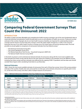
- Comparing Federal Government Surveys That Count the Uninsured: 2022 (Issue Brief)
- 2017-2021 ACS: 5-year Combined State and County Uninsured Rates (Blog, Interactive Map, & Data Tables)
For more detailed estimates on health insurance coverage in 2021, please visit State Health Compare. Be sure to also check out our helpful guide to Navigating Data on State Health Compare for more on what users can do with this unique data tool!
1 SHADAC also covers health insurance coverage data releases from both the National Health Interview Survey (NHIS) and the Medical Expenditure Panel Survey (MEPS). For more on the NHIS, see a recent blog post discussing the early release estimates from the first half of 2022, and for more on the MEPS, see the latest edition of our of Employer-Sponsored Health Insurance report.
2 Because of changes made in 2020 to how the ACS measures race and ethnicity, caution should be used when comparing data by race and ethnicity from 2021 and later to data from 2019 and earlier.
3 As previously documented by SHADAC, 2020 ACS data were unfortunately severely disrupted by the COVID-19 pandemic, resulting in the choice by the U.S. Census Bureau to release the estimates in an “experimental-only” capacity. For that reason, SHADAC created a special “Health Insurance Coverage Type (2020)” measure using data from the CPS. For more on the reasoning behind using the CPS instead of the ACS and the differences between the two surveys, please see our explanatory blog post.
Blog & News
Changing Population Estimates: Implications for Data Users
February 21, 2022:.
|
How the CDC’s recent shift will impact calculations for birth and death rates |
The National Center for Health Statistics (NCHS) at the Centers for Disease Control (CDC) recently changed the population estimates they use to calculate population-level rates in their National Vital Statistics System (NVSS), such as birth rates and mortality rates that are commonly accessed through tools such as CDC WONDER. These population estimates allow for the production of rates by providing a population denominator against which to compare the number of births or deaths.
Beginning with the 2021 data year, CDC transitioned from using "bridged-race" population estimates based on the race and ethnicity categories specified in the 1977 OMB Race and Ethnic Standards for Federal Statistics and Administrative Reporting to using "single-race" population estimates from the U.S. Census Bureau (“Census”) based on the race and Hispanic ethnicity categories specified in the 1997 OMB standards for the collection of data on race and ethnicity. The bridged-race estimates had been created to better align the population estimates from Census that used the 1997 OMB categories with the birth and death records from vital statistics systems that in many cases still used the 1977 OMB categories. This transition to the single-race population estimates appears to be precipitated by Census' recent improvement to their collection of race and ethnicity data beginning with Census 2020 data collection and continuing with subsequent years of the American Community Survey.
This move to single-race population estimates has several implications for data users:
- Statistics based on the single-race population estimates are only made available via CDC WONDER for data years 2018 forward, and statistics based on bridged-race population estimates are only available through data year 2020. Data users should not make comparisons between statistics based on bridged-race population estimates and statistics based on single-race population estimates. Further, because of changes made in 2020 to how Census measures race and ethnicity, caution should be used when comparing statistics by race and ethnicity from 2020 and later to data from 2019 and earlier.
- CDC WONDER has expanded the number of race and ethnicity categories available to data users. Previously, only five race categories and two Hispanic ethnicity categories were available. This has been expanded to up to 31 race categories and two Hispanic ethnicity categories.
- The single-race population estimates produced by Census suppress the number of persons less than five years of age at the county level to comply with Census' privacy policies. This prevents users from calculating age-adjusted rates at the county level or by level of urbanization using the single-race data, though crude rates can still be calculated at these levels of geography.
This change also affects SHADAC’s Suicide Deaths measure on State Health Compare. That measure’s Race and Ethnicity breakdown is now available in separate series for data years 1999–2020 and 2018–2021; estimates should not be compared between these series. Furthermore, SHADAC is unable to update the Metropolitan Status breakdown for this measure past data year 2020 due to the previously explained county-level suppressions.
Going forward, data users should keep changes in the denominator in mind when comparing annual estimates based on CDC vital statistics data. SHADAC strives to account for these types of considerations on State Health Compare by making clear when data years aren’t comparable and providing data users with relevant context around changes in methodology and data collection.


