The resources below were created by SHADAC with essential guidance from the advisory board of MNsure navigators and policymakers. These tools can be used for community-level equity-focused work and advocacy by informing strategic plans, partnership development, assessment of community needs, and grant-writing. Additionally, the tools support targeted outreach and enrollment activities of health insurance navigators and provide information about the uninsured to Minnesota policymakers as they develop strategies to reach the remaining uninsured in Minnesota.
This resource was originally developed as part of “Minnesota’s Uninsured and the Communities in Which They Live,” a project funded by the Blue Cross Blue Shield of Minnesota Foundation that supports targeted outreach and enrollment activities of health insurance navigators and provides information about the uninsured to Minnesota policymakers as they develop strategies to reach the remaining uninsured in Minnesota.
Community and Uninsured Profile (2018-2022) *UPDATED DATA*
This updated profile provides rates and counts of Minnesotans at the ZIP code (i.e., Census-defined ZIP code), county, economic development region, MNSure rating area, legislative district (senate and house), and state level using the latest estimates (2022) from the United States Census Bureau's American Community Survey (ACS). The profile features characteristics of the total population and uninsured population within a select community. The profile assists in identifying the different social factors that can influence the health of the population and factors that influence access to health insurance.
The profile also includes information about community-level Social Vulnerability at the ZIP code level using a Minnesota-specific version of the Center for Disease Control’s (CDC) Social Vulnerability Index (SVI).
|  |
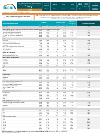 |
The Excel workbook includes four supplemental tabs and the “Profile” tab:
- Purpose: Describes the purpose of the project.
- How to Use: Describes how to view the uninsured profile for a specific community of interest, and walks through how to identify a community of interest.
- Community and Uninsured Profile: Profile of the characteristics of the uninsured and the community in which they live at the ZIP code, county, MNsure rating area, economic development region, or state level. It also includes regional hotspot status and SVI information.
- ZIP Code Uninsured Rates: Sortable spreadsheet including all the reported Census-defined ZIP Codes, counties, and regions, the number and percent of uninsured within those communities, as well as the regional hotspot status and level of community social vulnerability.
- Data Definitions, and Notes: Provides all the definitions for the profile tab as well as the data source and notes.
- ZIP Code with No Available Data: Data for some Census-defined ZIP codes were suppressed if the relative standard error (SE/estimate) was greater than 30% or the number of uninsured was less than 50.
Additional Technical Assistance and Profile Customization
SHADAC can provide additional technical assistance, profile customization, and analysis to organizations that rely on the Profile in their work. This personalized work can give organizations additional information relevant to the populations they serve or can retool information presented in the Profile to make it more specifically relevant to an individual organization's needs.
This could include creating statistics for specific geographies or specific populations, bringing in information from new data sources to provide important context, or tailoring existing Profile information to create bite-sized and actionable data products specifically relevant to individual organizations that use the Profile in their work. If you're interested in working with us or utilizing our expertise & assistance, please contact us here or email shadac@umn.edu.
Community and Uninsured Profile Video Tutorial
This video was produced with a previous iteration of this resource and provides a tour of the Community and Uninsured Profile. The profile contains information about different geographic areas in Minnesota, the demographics and characteristics of the community within that geographic area, as well as the uninsured who live in those areas. The geographic areas included are zip codes, counties, regions, legislative districts, MNsure rating areas, and the state. The profile can be used in two ways: (1) to support other equity-focused work, advocacy work, strategic planning, community needs assessments and grand-writing, and (2) to target health insurance coverage outreach and enrollment efforts.
Interactive Map

We have also created an interactive map designed to be used alongside the profile. This allows users to view uninsurance data in Minnesota by zip code, region, county, and social vulnerability index (SVI), amongst others. The map also allows users to view the location of hospitals, reservations, senate & house districts, and many more.
We would greatly appreciate your feedback on the community and uninsured profile. Share your suggestions with us here.